





Topographic Survey at Garner Lake
February 18, 2025|1 min. read

On February 24-25, Core Geomatics will be conducting an initial topographic survey at the Garner Lake Boat Launch. This work is required for the design of the new boat launch slated for construction this summer.
For this survey, Core Geomatics will be completing lake bed tie-ins, meaning they will be drilling 15-20 holes in the ice to determine lake depths throughout. The work area will be marked in the field with lath.
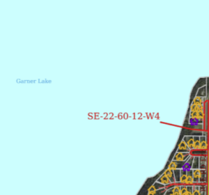
As this work may pose a safety risk, those who frequent the lake (residents, snowmobilers, ice fishers) are asked to take care on the ice and mind the work area. If you have any questions about this work, please call Public Works at 780-645-3006.
Share:


Search
Categories
Recent Posts

More news
2026-27 Winter Snow Flags available for purchase
The County of St. Paul is now accepting new and ...
Read more 
Group fundraising available, Elections Alerta
Elections Alberta is accepting applications for the Group Election Worker ...
Read more 
For Lease by Tender, proposed terms
The County of St. Paul No. 19 is accepting tenders ...
Read more 

